2 How the Plan Works
2.1 Statutory Context
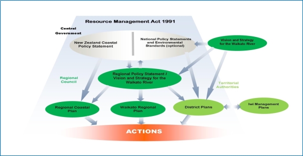
District plans are prepared within a hierarchy of policy statements and plans that along with the RMA form the statutory context. This hierarchy consists of the Vision and Strategy for the Waikato River, national and regional policy statements, national environmental standards, and regional plans prepared under the RMA, and iwi planning documents, and management plans and strategies prepared under other legislation (for example the Conservation Act and Heritage New Zealand Pouhere Taonga Act 2014). This district plan has been formulated having considered this statutory framework.
2.1.1 Vision and Strategy for the Waikato River
The Vision and Strategy for the Waikato River (Te Ture Whaimana o Te Awa o Waikato) came into effect via the Waikato Raupatu Claims (Waikato River) Settlement Act 2010 and the Ngāti Tūwharetoa, Raukawa, and Te Arawa River Iwi Waikato River Act 2010. The Vision and Strategy is the primary direction-setting document for the Waikato River and activities within its catchment affecting the River. It has been deemed in its entirety into the RPS and regional and district plans must give effect to it.
The Vision and Strategy prevails over any inconsistent provision in the Regional Policy Statement, a National Policy Statement and/or the New Zealand Coastal Policy Statement, and a district plan must give effect to it. A district plan rule adopted for the purpose of giving effect to the Vision and Strategy prevails over a national environmental standard. The South Waikato District Plan therefore has a duty to implement the Vision and Strategy when carrying out its statutory functions under the Resource Management Act 1991.
The Waikato River Authority (WRA) is the statutory body responsible for setting the direction through the Vision and Strategy to achieve the restoration and protection of the health and wellbeing of the Waikato River for present and future generations. It is required to review the Vision and Strategy at least every 10 years and district and regional plans must be reviewed within 12 months of this happening.
For this reason the Vision for the Waikato River and the Objectives for the Waikato River and the Strategies for the Waikato River are recorded in full below, followed by a summary of the key references as to how this district plan is going to give effect to the Vision and Strategy.
The Vision and Strategy’s stated vision “is for a future where a healthy Waikato River sustains abundant life and prosperous communities who, in turn, are all responsible for restoring and protecting the health and wellbeing of the Waikato River, and all it embraces, for generations to come”.
In order to realise the Vision, the following Objectives will be pursued:
“A) The restoration and protection of the health and wellbeing of the Waikato River.
B) The restoration and protection of the relationship of Waikato-Tainui with the Waikato River, including their economic, social, cultural, and spiritual relationships.
C) The restoration and protection of the relationship of Waikato River Iwi according to their tikanga and kawa, with the Waikato River, including their economic, social, cultural, and spiritual relationships.
D) The restoration and protection of the relationship of the Waikato Region's communities with the Waikato River, including their economic, social, cultural, and spiritual relationships.
E) The integrated, holistic and coordinated approach to management of the natural, physical, cultural and historic resources of the Waikato River.
F) The adoption of a precautionary approach towards decisions that may result in significant adverse effects on the Waikato River, and in particular those effects that threaten serious or irreversible damage to the Waikato River.
G) The recognition and avoidance of adverse cumulative effects, and potential cumulative effects, of activities undertaken both on the Waikato River and within its catchments on the health and wellbeing of the Waikato River.
H) The recognition that the Waikato River is degraded and should not be required to absorb further degradation as a result of human activities.
I) The protection and enhancement of significant sites, fisheries, flora and fauna.
J) The recognition that the strategic importance of the Waikato River to New Zealand's social, cultural, environmental and economic wellbeing is subject to the restoration and protection of the health and wellbeing of the Waikato River.
K) The restoration of water quality within the Waikato River so that it is safe for people to swim in and take food from over its entire length.
L) The promotion of improved access to the Waikato River to better enable sporting, recreational and cultural activities.
M) The application to the above of both maatauranga Maaori and latest available scientific methods”.
To achieve the Objectives, the following Strategies will be implemented:
1. “Ensure that the highest level of recognition is given to the restoration and protection of the Waikato River.
2. Establish what the current health status of the Waikato River is by utilising mātauranga Maori and latest available scientific methods.
3. Develop targets for improving the health and wellbeing of the Waikato River by utilising mātauranga Māori and latest available scientific methods.
4. Develop and implement a programme of action to achieve the targets for improving the health and wellbeing of the Waikato River.
5. Develop and share local, national and international expertise, including indigenous expertise, on rivers and activities within their catchments that may be applied to the restoration and protection of the health and wellbeing of the Waikato River.
6. Recognise and protect wāhi tapu and sites of significance to Waikato-Tainui and other Waikato River Iwi (where they so decide) to promote their cultural, spiritual and historic relationship with the Waikato River.
7. Recognise and protect appropriate sites associated with the Waikato River that are of significance to the Waikato regional community.
8. Actively promote and foster public knowledge and understanding of the health and wellbeing of the Waikato River among all sectors of the Waikato regional community.
9. Encourage and foster a 'whole of river' approach to the restoration and protection of the Waikato River, including the development, recognition and promotion of best practice methods for restoring and protecting the health and wellbeing of the Waikato River.
10. Establish new, and enhance existing, relationships between Waikato-Tainui, other Waikato River Iwi (where they so decide), and stakeholders with an interest in advancing, restoring and protecting the health and wellbeing of the Waikato River.
11. Ensure that cumulative adverse effects on the Waikato River of activities are appropriately managed in statutory planning documents at the time of their review.
12. Ensure appropriate public access to the Waikato River while protecting and enhancing the health and wellbeing of the Waikato River".
Approaches adopted in this district plan to give effect to the vision are:
Two of the six significant resource management issues facing the district are specifically directed to achieving the Vision and Strategy; namely:
(a) Restoring and Protecting the health and wellbeing of the Waikato River; and
(b) Recognising Tangata Whenua Values.
The remaining four significant resource management issues together provide for a holistic approach to promoting sustainable resource management in decision-making, namely:
(i) Enhancing the vibrancy of the district’s towns
(ii) Safeguarding established rural land-uses and the productive potential of the rural areas
(iii) Managing landscape, natural values, and indigenous biodiversity
(iv) Managing and providing for infrastructure, communications and major industrial sites.
The key objectives and policies to address these issues are set out in Parts 2 and 3 of this plan, as are the supporting plan rules.
2.1.2 National and Regional Planning Documents
The most relevant national planning documents are national policy statements and national environmental standards prepared by central government (for a list of these see Chapter 4. District Plans cannot contain any rules that could conflict with regulations in an NES.
Part of the Waihou River catchment is in the District. The Hauraki Gulf Marine Park Act 2000 gives special recognition to the Hauraki Gulf, its islands and catchments". This requires the Council when exercising its powers in relation to the Waihou catchment to have particular regard to matters set out in section 7 and section 8 of this Act. The relationship with the Resource Management Act is also recorded in section 9 to require that the District Plan "does not conflict with" section 7 and section 8. Council therefore has a duty to consider these provisions when determining resource consent applications. Plan provisions further recognise this duty with specific policy and rules that are focused on forestry conversion and riparian management.
At the regional level, the key planning documents are the Waikato Regional Policy Statement (RPS), the Waikato Regional Plan and the Regional Land Transport Strategy prepared by the Waikato Regional Council.
District plans must ‘give effect to’ national policy statements and the regional policy statement and must not be ‘inconsistent with’ the regional plan. The RPS provides the direction on many strategic planning issues for the region, and the district plan has been formulated to give effect to the Waikato RPS. The Regional Land Transport Strategy sets the strategic framework for long term development of the regional transport system and is therefore also relevant.
Iwi planning documents, such as the Environmental Management Plan 2015 prepared by Raukawa, are also important documents that need to be taken account of in district and regional planning.
The aim of the district plan is to apply the broad policy approaches adopted at the regional level to the local context of the district, without overlapping or confusing the respective roles prescribed in the RMA.
Figure 1: Relationship between policy and planning instruments
2.2 Relationship to other district strategies and plans
The district plan also has a relationship with other strategies and plans prepared by South Waikato District Council. The Long-Term Plan prepared under the Local Government Act 2002 establishes community outcomes in terms of social, cultural, economic and environmental matters, and outlines Council’s responses to those in terms of budget priorities and programmes.
Council has prepared Asset Management Plans, Reserve Management Plans, and Concept Plans for the towns, all of which provide a broader context to the district plan.
These strategies and plans have all been used in formulating the district plan. The plan is a key implementation tool for achieving the environmental aspects of the community outcomes and visions outlined in the Long-Term Plan and other documents listed above.
2.3 General Approach
The district plan is comprised of four interrelated parts:
- Part 1 – Introduction and General provisions
- Part 2 – District-wide Matters
- Part 3 – Area Specific Matters
- Part 4 – Appendices and Planning Maps
(a) Part 1- Introduction and General Provisions
(i) These chapters explain the District Plan’s context and how it works, and provide definitions that assist to interpret the District Plan. They also provide context and process-related information in relation to Tangata Whenua.
(b) Part 2- District Wide Matters
(i) Strategic Matters: The strategic matters address key strategic and/or significant matters for the district and provide district-wide strategic considerations to guide decision making at a strategic level. All other objectives and policies in the District Plan are to be read and achieved in a manner consistent with these matters. The strategic objectives where provided for, are not repeated in the other chapters in the District Plan but are given effect to by policies within those relevant chapters. For the purpose of plan development, including plan changes, the strategic objectives provide guidance on the key strategic or significant matters for the district that are relevant when developing District Plan provisions. For the purpose of plan implementation (including in the determination of resource consent applications and notices of requirement), the strategic objectives (where provided) provide guidance on what the related objectives and policies in other chapters of the District Plan are seeking to achieve in relation to key strategic or significant matters for the district.
(ii) District-wide Matters: These relate to:
- specific areas, including overlays (e.g. heritage, sites of significance to Māori, significant natural areas etc). An overlay chapter spatially identifies distinctive values, risks or other factors that require management in a different manner from underlying zone provisions. A number of overlays relate to matters of national importance under the Act;
- specific activities that occur across the district (e.g. noise and earthworks).
(c) Part 3- Area Specific Matters
(i) Zones: A zone spatially identifies and manages an area with common environmental characteristics or where particular environmental outcomes are sought. The entire district is zoned and all land is identified as part of a 'zone' on the planning maps, with rules which manage activities in that particular zone. The zones seek to enable similar, compatible activities or effects to be located in appropriate areas together, while managing those that are incompatible.
(ii) Precincts: A precinct spatially identifies and manages an area where additional place-based provisions apply to modify or refine aspects of the policy approach or outcomes anticipated in the underlying zone(s).
(iii) Development Areas: A development area identifies and manages areas that are suitable for urban growth purposes, where a structure plan applies. Additional provisions apply to enable integrated and coordinated growth in accordance with the plan for each area.
(iv) Designations: these areas identify where a designation is included in the District Plan under section 168, section 168A or clause 4 of Schedule 1 of the Act. Designations authorise the use of land for a particular project or public work (such as a school, police station, state highway, substation or other infrastructure). The District Plan rules do not apply to a public work, project or work undertaken by a requiring authority pursuant to the designation. However, if the designated land is used for a purpose other than the designated purpose, then the provisions of the District Plan do apply. Other people may not, without the prior written consent of the requiring authority, do anything in relation to the designated land that would impede the public work, project or work.
(d) Part 4 – Appendices and Planning Maps
(i) These contain technical information and data, such as the Heritage Inventory and Catchment Stream patterns and landuse.
(ii) Electronic planning maps spatially define zones, areas, overlays and features referred to within the District Plan chapters.
Within Part 2 (excluding the Strategic Direction chapters, which only contain objectives in some instances) and Part 3 of the District Plan, each chapter contains objectives, policies, rules and standards to address resource management issues.
2.4 How to use this District Plan
When using the plan, the following steps should be followed:
Figure 2- Steps in using the district plan
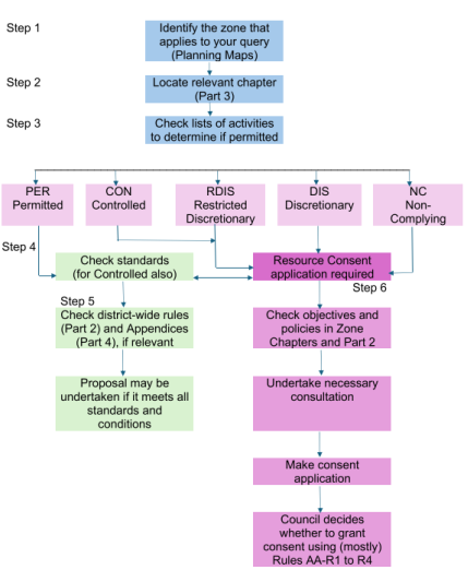
Step 1
Using the plan maps identify the zone that applies to the particular area your enquiry relates to. You then need to identify whether there are any overlays or other notations on the particular site your enquiry relates to.
Step 2
Then locate the relevant zone chapter in Part 3 of the plan for the particular site or area your enquiry relates.
Step 3
Within the zone chapter there are lists of land-use activities that are identified as being PER (permitted) activities (no resource consent required provided all standards are met), CON (controlled) activities, RDIS (restricted discretionary) activities, DIS (discretionary) activities and NC (non-complying )activities (all of which require resource consent to be obtained prior to carrying out the activity).
The definitions in Chapter 3 contain the meaning of particular terms used in the plan and should be referred to for checking which listed activity a particular proposal fits into.
Step 4
The zone chapter then contains a series of standards. For an activity that was identified in Step 3 as being a PER activity, compliance with all standards is necessary for the activity to remain a PER activity and therefore not require resource consent.
For an activity that was identified in Step 3 as being a CON, RDIS, DIS or NC Activity, then compliance with the standards still needs to be checked and may alter the type of resource consent you require.
Step 5
At the end of each zone chapter, there is a list of Other Plan Matters that may also be relevant.
Part 4 of the plan contains various supporting appendices that may also be relevant depending on the particular enquiry. The appendices are referred to in some standards and rules.
Step 6
Once the above steps have been followed, if it is determined that an activity is not a PER Activity (either because of the activity lists, or because one or more standards or rules are not complied with), then a resource consent application will be required. Chapter 12 contains information relating to making a consent application, including the specific matters to be addressed.
The objectives and policies provide the policy framework that resource consent applications will be assessed against. In broad terms, the more an application can demonstrate that the objectives and policies of the plan overall are being met, the more likely that consent will be granted.
2.5 Managing cross boundary matters
There are some environmental issues that cross local authority boundaries and jurisdictional boundaries and need to be managed in a coordinated and consistent manner between local authorities for effective and efficient integrated management to be achieved.
The adjoining local authorities are Otorohanga District, Waipa District, Taupō District, Rotorua District, Matamata- Piako District and Western Bay of Plenty District. The plan has been formulated to achieve consistency with provisions in other district plans where possible, particularly for land-uses like forestry, farming and energy generation that extend across into adjoining districts.
The provisions managing outstanding landscapes, significant natural areas, network utilities and activities on the surface of the water have also been formulated to provide some consistency with the approaches of adjoining districts where possible.
“Cross-boundary” matters apply not only to geographical boundaries between different districts, but also to jurisdictional boundaries with the Waikato Regional Council. For example, the RMA gives responsibilities to both district and regional councils in the management of indigenous biodiversity, and the actions of both agencies need to be co-ordinated to avoid overlaps and ensure the best environmental outcomes are achieved.
The processes that the Council will use to resolve any issues that cross local authority boundaries and jurisdictions include:
(a) Liaison and facilitation of joint actions with other local authorities to deal with cross boundary issues as they arise.
(b) Information sharing between local authorities.
(c) Inform and consult with other local authorities on consent applications, or plan change requests, where a potential cross-boundary effect may occur.
(d) Initiate and participate in joint hearings with the other local authorities where appropriate, to better achieve integrated resource management.
(e) Make submissions on plans and policy statements prepared by other councils, to achieve consistent approaches wherever possible in managing resources that cross local authority boundaries or jurisdictions.
(f) Identify, in conjunction with the regional council, opportunities for local authorities to transfer functions to each other or to the regional council where this would result in more efficient, effective and integrated resource management.
2.6 Monitoring Environmental Outcomes
Anticipated environmental results are identified within each zone and rule chapter. The aim of this is to define the desired environmental outcomes to be achieved by the provisions for a particular zone or by a rule chapter.
The anticipated environmental results have been written in a manner that they can be measured to enable the effectiveness of the plan to be evaluated in future years.
2.7 Relationship Between Spatial Layers
The overall activity status of a proposal will be determined on the basis of all rules which apply to the proposal. When a proposal involves several activities that are subject to multiple rules with different activity statuses, or involves an activity/activities across multiple zones, precincts, areas, overlays or features, and it is appropriate to "bundle" the activities, the proposal will be assessed on the basis of the most restrictive activity status.
If an activity is covered by more than one rule, then all the relevant rules apply and no rule has precedence over another.
Overlay Chapters only include rules for certain types of activities. If your proposed activity is within an overlay, but there are no overlay rules that are applicable to your activity, then your activity can be treated as a permitted activity under the Overlay Chapter, unless stated otherwise. Resource consent may still be required under other Part 2: District-wide Matters chapters and Part 3: Area-Specific chapters. When an activity/activities are proposed on a site that is subject to different zones (i.e. a non-cadastral boundary or split zone), the underlying zone where the activity is proposed to locate in will apply.
An application for resource consent for a proposal must address all rules under which consent is required for that proposal under the District Plan and all relevant matters, or must clearly set out the reason why the application is not in relation to all such matters.