Part 2 – District Wide Matters
6 Matters of Strategic Direction
Purpose
The purpose of this chapter is to provide a statement about the significant resource management issues that the district is facing. The issues describe what the district plan needs to broadly address in the South Waikato District to achieve the purpose of the Resource Management Act (the RMA).
The discussion below highlights six significant resource management issues facing the district. Objectives and policies can be found in Part 2 and Part 3 of the Plan.
6.1 Enhancing the Vibrancy of the District’s Towns
A significant resource management issue for the district is to enable the district’s towns to become more vibrant places, but in a manner that protects and enhances existing amenity values and character and within a context of static or modest district-wide growth.
The towns in the district perform a key role in the functioning of the district. The towns are where most people in the district live, where much of the employment is located, and where most of the community facilities are located such as schools, medical facilities, libraries, parks and shops. These facilities and services support the social well-being of both the residents of the town and also the surrounding rural hinterland. Contributing to the success of the towns by making them more attractive places to live, work and play, and improving the way they function are therefore key issues. The ongoing prosperity of the towns is necessary for them to provide the range of community facilities and services necessary for all residents in the district.
The growth projections for the district are for static or modest population growth. The focus of the plan is therefore to provide flexible provisions to encourage new forms of development within the towns, and with a focus on achieving better urban design outcomes and revitalisation. Growth will not be the primary driver of urban change and therefore the plan has sought to identify other catalysts for promoting positive change. The plan aims to facilitate the re-development of existing properties within a flexible framework that achieves good urban design outcomes and enhances the appearance and functioning of the towns.
The town centres within each town are important to the identity and functioning of the towns. Improving the attractiveness and character of the town centres is a key element, and all of the town centres have the capacity to accommodate additional development. The district plan can contribute to this by using zoning to direct commercial growth primarily to the town centres to ensure they thrive, and direct industry and employment to the industrial parts of the town.
Each of the towns also has distinctive features that need to be recognised and provided for through plan provisions. Protecting heritage buildings and places is important to maintaining the distinctive character of the towns. It is recognised that some of the towns in the district also contain strategic land-uses of a more industrial nature (such as industrial parks and primary production processing facilities), that requires particular consideration. Zone provisions through Precincts have been formulated that are specific to each of the towns to recognise and provide for their particular characteristics.
Tokoroa, Putaruru and Tīrau all have the capacity to support increases in population and employment growth within the existing boundaries of the towns. The towns each have infrastructure networks that contribute to the functioning of the towns in a sustainable manner. These networks are roading, walkways, water supply, stormwater and wastewater, and are adequate, although they are aging and will require ongoing investment. The plan seeks to support the success of each of the towns through a flexible regime of provisions that aims to enable growth and good urban design outcomes.
Arapuni is a village set within an attractive rural part of the district and has a distinctive character and identity. Plan provisions have been formulated to recognise and maintain this character and identity, and to contribute to the overall wellbeing of the Arapuni community through the Mixed Use Settlement Zone.
6.2 Managing and Providing for Infrastructure,
Communications and Major Industrial Sites
The district’s economy relies heavily on the ability to connect with the remainder of the Waikato region and beyond. Infrastructure, transportation and communications networks therefore perform a key role in the prosperity of the district. There are also several major industrial sites in the district that contribute significantly to the district’s economy but can generate adverse environmental effects that must be managed within defined parameters.
A significant resource management issue for the district is the need to enable the district’s new and existing network utilities and infrastructure and major industrial sites (including adequate connections to services) to operate efficiently and effectively to provide for the community’s social and economic needs, whilst managing potential adverse environmental effects from those activities, and avoiding ad hoc development of sensitive or incompatible land-uses close to existing networks and sites.
The major industrial sites in the district are significant employment nodes, represent substantial financial investment at a fixed location, and are considered strategic assets given their role in the regional and national economy. These comprise the industrial facilities at Kinleith, the dairy processing activities at Tīrau, Lichfield and Tokoroa, hydro-electric generation on the Waikato River, and the industrial estates in Putaruru and Tokoroa. Provisions have been formulated in the plan to manage the particular environmental issues associated with these sites, by requiring the operators to manage the effects within identified parameters to protect the environment. Furthermore, to manage reverse sensitivity effects by preventing inappropriate development close to these sites.
The district is a major electricity producer with the Waikato Hydro Scheme consisting of a series of hydroelectric power stations along the length of the Waikato River. The Waikato Hydro Scheme is nationally significant in terms of the country’s energy needs. The electricity generated in the district utilises the Electricity Transmission Network operated by Transpower New Zealand to relay that electricity to major population centres elsewhere in the country. A National Policy Statement on Electricity Transmission (NPSET) came into effect in 2008. The NPSET confirms that the Electricity Transmission Network is a nationally significant physical resource that must be sustainably managed, and any adverse effects on that infrastructure must be avoided, remedied or mitigated.
Increasingly, the district is likely to also provide other renewable energy sources such as geothermal, wind, solar and biomass. The plan seeks to encourage the sustainable development of renewable energy generation in the district.
A National Policy Statement for Renewable Energy Generation came into effect in May 2011. This Statement sets out the need to develop and maintain renewable electricity generation activities and to recognise the benefits of renewable electricity generation as matters of national significance. The provisions of the district plan have therefore been designed to give effect to the NPS.
The district also has several other nationally significant transportation and gas transmission corridors. Nationally significant rail and road connections link the district to airports, ports and freight hubs in Hamilton, Tauranga and Auckland, and also connect the district’s economy to those markets. Roading within the district also forms an important part of the district’s economic performance with a network of state highways, local roads, and private forestry roads.
The plan recognises and protects the national and regional infrastructural, transportation and communications facilities and corridors through the district, and seeks to manage the various renewable energy resources the district possesses. This includes aiming to minimise “reverse sensitivity” effects of incompatible development occurring too close to these facilities and corridors.
Increasingly telecommunications and radio communications and broadband are performing a critical function in generating economic activity and connecting businesses and people globally. The plan seeks to facilitate ongoing infrastructural and telecommunications development within the district as a means to ‘unlock’ the economic potential of the district.
Facilitating infrastructure development will require balancing environmental and amenity effects with the functional requirements of the infrastructure, to deliver an efficient regulatory framework within the plan.
6.3 Managing Landscape, Natural Values and
Indigenous Biodiversity
Within the South Waikato district there are outstanding landscape areas and outstanding landscape features, and significant natural areas, and riparian margins with important natural character. In these areas the landscape attributes and natural values must be considered along with impacts on indigenous biodiversity more generally, in determining the suitability of land-uses and development proposals. A significant resource management issue for the district is to protect the values of these outstanding landscapes, landscape features, significant natural areas, riparian margins and indigenous biodiversity. This must be done together with the maintenance and enhancement of amenity values and the quality of the environment, whilst enabling land-uses and development to occur in a manner and at a scale that can be undertaken without detrimentally impacting on those values.
The Waikato RPS provides direction as to the identification and protection of these landscapes and significant natural areas. Using the criteria of the RPS, Council has identified the location and extent of the landscapes, and the particular attributes and values that need to be managed. A programme of work to confirm and map the extent of significant natural areas has been completed. District plan provisions have sought to achieve a balance between recognition and protection of landscape and natural values and enabling continuation of existing land-uses and development within these environments where that can be undertaken without detrimentally impacting on those values.
Protection of the outstanding landscape and landscape features in the district is a matter of national importance within the RMA. The RPS has identified the landscapes considered to be of regional significance. Other landscapes and landscape features that are considered to be outstanding in a district context have been recognised through plan provisions.
Identification and protection of significant natural areas (significant indigenous vegetation and significant habitats of indigenous fauna); the preservation of the natural character of wetlands, lakes and rivers and their margins; and the maintenance and enhancement of public access to lakes and rivers; are all matters of national importance in the RMA. The plan has sought to address all of these matters.
There has been a gradual decline in the number and extent of significant natural areas in recent years, and of indigenous biodiversity as a whole. This decline is now generally the result of a lack of active management of sites, in most cases, rather than actual clearance of indigenous vegetation (now limited and generally small scale, as compared with the large scale loss of indigenous vegetation and habitats that occurred during the main phases of land development), drainage of wetlands, or significant modification of landforms. Pest and weed encroachment and related adverse effects, stock browsing, and modification of waterways and riparian margins have all played a part in the decline of biodiversity in the district. The district plan forms part of the response to this ongoing loss of biodiversity in the district.
There are a number of significant water bodies in the district, consisting of the Waikato and Te Waihou Rivers, the Pokaiwhenua Stream, and the many lakes, wetlands, streams and springs. Many of these water bodies have significant cultural values in addition to their landscape and natural values. Raukawa and TARIT are statutory partners in managing the Waikato River given the co-management arrangements now in place. Much of the length of the Waikato River through the district is highly modified, with the hydro dams creating a series of lakes where water levels fluctuate within the range of Mercury Energy’s consented hydro operating regime.
Water quality within these water bodies is strongly related to adjoining (and upstream) land-uses, farming and forestry management practices, and the extent of riparian planting. There has been substantial land-use change in the district in recent years. The conversion of exotic plantation forest into dairy farms can have environmental impacts including reduced freshwater quality, increased peak flood flow, lost carbon sinks and reduced biodiversity. In particular the potential impact on biodiversity in the Waikato River, its tributaries and other waterways in the district will need to be addressed. This plan uses esplanade strips to facilitate riparian planting for water quality purposes along priority streams. Such planting will help to give effect to the Vision and Strategy for the Waikato River.
6.4 Recognising Tangata Whenua Values
A significant resource management issue for the district is to better recognise and provide for Tangata Whenua values in resource management decision-making.
Raukawa exercise mana whenua and the rights and responsibilities of kaitiakitanga within their rohe, which includes the entire South Waikato District. Recognising and providing for the relationship of Māori and their culture and traditions with their ancestral land, water sites, wāhi tapu and other taonga is a matter of national importance under the RMA (section 6(e)). Section 7 of the RMA requires local authorities to have particular regard to kaitiakitanga and Section 8 requires the principles of the Treaty of Waitangi to be taken into account.
Legislation passed in 2010 introduced co-management responsibilities for the Upper Waikato River and its catchments, heralding a new level of relationship and engagement between Tangata Whenua and local and central government. Raukawa and TARIT have entered into Joint Management Agreements with Council under this legislation.
The district plan has sought to recognise and provide for the relationship that Raukawa have with the natural and physical resources of the district, and to better safeguard the significant Tangata Whenua values of the district. Issues of concern to Raukawa include both environmental issues and process issues. Less relevant to the district plan but equally important to Raukawa are social issues such as access to and affordability of housing, and implementation and understanding of the principles of the Treaty of Waitangi. Raukawa places significant value on its relationship with its many partners and stakeholders, including industry, farmers, the Council and the community, and seeks to work in a practical and pragmatic way with all sectors to achieve the environmental aspirations of the iwi.
The Raukawa understanding of the natural environment of the South Waikato goes back over 600 years. In this time the district has faced significant change and environmental losses.
Raukawa consider that the most important resource management matters affecting them in the South Waikato are:
1. Adverse effects on the health and wellbeing of waterways - While there is particular emphasis on the Waikato River all waters including awa (rivers), manga (streams), roto (lakes) and puna (springs) are considered taonga. The Waikato and Waihou Rivers are a source of spiritual, cultural, social and physical sustenance for Raukawa, and in turn the Raukawa role as kaitiaki embraces respect and an inter-generational responsibility for the rivers.
2. The loss of wetlands – Wetlands are important for water quality, biodiversity, flood protection and indigenous biodiversity. They are also a traditional source of food and material (such as for building, weaving and medicines) for Raukawa. The district (and region) has lost the majority of its wetlands.
3. Adverse effects on Papatūānuku – The land continues to be damaged through inappropriate land use practices. Impacts include historical and ongoing contamination of land, loss of productive soils and accelerated erosion.
4. Poor air quality – Tokoroa and Putaruru airsheds have not met the National Environmental Standards for Air Quality. Adverse effects of poor air quality include social (human health), environmental and economic (cost of reducing non-compliance and potential for limiting economic growth through restrictions on new businesses if the situation is not addressed).
5. Loss of indigenous biodiversity – There has been significant loss of indigenous biodiversity in the district. In addition to having intrinsic values, native species were and continue to be important resources to Raukawa. Plants and animals were harvested as kai, rongoa (medicine), building materials, and as dye and weaving materials for clothing and decoration. Biodiversity also provides ‘ecosystem services’, such as clean air and water, fertile soils and flood control which enable us to live and make a living within the district.
6. Loss of cultural heritage – Including cultural landscapes, wāhi tapu and other sites of significance, access to places and resources (such as rongoa and mahinga kai), loss of traditional names. The district includes many wāhi tapu, wāhi taonga, and other sites of significance. Effective systems, information, and resources need to be utilised to preserve, enhance, record and provide for these historical and cultural taonga. Cultural landscape values are still largely unrecognised, poorly understood and very little protection of these values is afforded. Archaeological sites however have legal protection under the Heritage New Zealand Pouhere Taonga Act 2014.
7. Barriers to sustainable marae and papakāinga development – There have been a number of barriers that have restricted the development of marae and papakāinga. Marae are important not only to Raukawa but also to the wider community – they are often used as meeting venues and civil defence bases for example.
8. Barriers to practical and contemporary expression of kaitiakitanga – Includes Council processes, relationships etc. The Raukawa role as kaitiaki and mana whenua within their rohe has been diminished and continues to be adversely affected by processes such as those administered under the RMA and LGA. Inadequate and inappropriate processes mean Raukawa are involved at the end and not the beginning of processes, are insufficiently resourced to participate in a meaningful way, often lack information to be able to engage in issues, and traditional or customary knowledge and systems are marginalised. Lack of understanding of how the principles of the Treaty of Waitangi should be applied has led to poor outcomes and poor engagement generally. This applies to the community in its widest sense.
9. Unsustainable development – There is a need to ensure that development in the district is sustainable in the long-term and meets the needs of the whole community. This includes adopting best practice urban design and low impact design principles, providing for a range of housing styles and options, and ensuring developments have access to adequate services and utilities. Many Tangata Whenua continue to live on traditional or customary lands which are often in remote parts of the district. Such areas often experience lesser levels of service than urban areas, such as roading, waste management, health and education services, public transport, telecommunications and internet access, and access to sufficient water. The provision of appropriate and accessible housing for iwi within and around the district continues to be an issue. This is a complex and important issue involving poor quality housing, inappropriate size of housing available, lack of housing available on customary lands and in papakāinga development, and insufficient assistance with new and innovative building designs. In recent years South Waikato’s towns have experienced slow growth and development. This has led to largely market-driven design, instead of design and provision for all of the members of the community including young and old people. Nor has design accounted for best practice such as using Crime Prevention through Environmental Design principles.
10. Failure to adopt an integrated and holistic approach to resource management – The current lack of a holistic approach and recognition of connections between issues. This applies to both providing for the linkages between elements of the environment, as well as the integration between those who have roles and responsibilities in managing the environment. This has led to adverse effects on the environment, including particularly cumulative effects.
Objectives
TW-O1 The Health and Wellbeing of the Waikato River
To restore and protect the health and wellbeing of the Waikato River and to ensure that the objectives of the Vision and Strategy for the Waikato River are achieved.
TW-O2 Waikato River Vision and Strategy – Co-management
To achieve co-management with Tangata Whenua of the Waikato River and its catchment, to give effect to the Vision and Strategy for the Waikato River.
TW-O3 Papatūānuku Integrated and holistic resource management / Cumulative effects
To manage the use, development and protection of natural and physical resources in a way that recognises the relationship of Māori and their culture and traditions with their ancestral lands, water, sites, wāhi tapu and other taonga and by enabling appropriate use of, and access to, them.
TW-O4 Cultural Heritage
To recognise and provide for the cultural, spiritual, economic and social values of Tangata Whenua when managing the District’s natural and physical resources.
TW-O5 Marae and Papakāinga
To ensure that Māori land is developed in a way that recognises the significance of the location to Māori and is consistent with traditional, cultural relationships and ownership arrangements, while appropriate health, safety and environmental standards are maintained.
TW-O6 Kaitiakitanga
To acknowledge and provide for the kaitiaki role of tangata whenua when assessing proposals for subdivision, use and development.
TW-O7 Treaty of Waitangi
To ensure that the principles of the Treaty of Waitangi are taken into account in all aspects of resource management within the South Waikato District.
TW-O8 Public Access
To improve public access to the Waikato River, Te Waihou and other waterways within the District to better enable recreational and cultural opportunities.
Policies
TW-P1
Recognise and provide in decision-making for the relationship of Māori and their culture and traditions with their ancestral lands, water, sites, wāhi tapu (sacred sites), and other taonga (treasures), including by improving public access to rivers and other waterways.
TW-P2
To achieve the objectives of the Waikato River Vision and Strategy within the catchment area identified on the planning maps by plan provisions relating to:
(a) building setbacks adjacent to waterways
(b) managing the effects of large-scale land-use change
(c) earthworks and silt control
(d) activities on the surface of water
(e) esplanade reserves/strips
(f) landscape protection
(g) preservation of natural character
(h) bonus lot provisions for Significant Natural Areas and in some cases riparian areas.
(i) managing the demand for the supply and discharge of water to keep within consented limits.
TW-P3
Give effect to the Vision and Strategy for the Waikato River when considering resource consent applications and in reviewing, changing and administering the district plan.
TW-P4
Provide for marae and papakāinga development on Māori land subject to compliance with health, safety and environmental standards and ensure such development occurs in a way which allows for potential future requirements, including infrastructure provision and by enabling Māori to provide for their economic self-sufficiency.
TW-P5
Give effect to co-management through establishing processes for engagement and early involvement in key processes, including RMA policy and plan making and resource consent processes, to ensure matters of significance to Māori are fully considered.
TW-P6
Have regard to relevant planning documents such as the Raukawa Environmental Management Plan when considering resource consent applications and in reviewing, changing and administering the district plan.
TW-P7
Identify sites of cultural, traditional, and spiritual significance to Māori, including cultural landscapes and ensure appropriate protection is provided to them through agreed plan making and resource consenting processes.
TW-P8
Improve public access to and along the Waikato River, Te Waihou and other waterways by requiring esplanade reserves or esplanade strips at sites identified on the planning maps at the time of subdivision and by keeping options open for future public use of the river edge through enforcing building setbacks.
TW-P9
Encourage the sustainable development of marae and other facilities required for the cultural needs of Tangata Whenua.
TW- Principal Reasons
PR1
Local government in New Zealand operates under a range of pieces of legislation, but most notably the RMA, and the Local Government Act 2002. Both statutes require local government to work with Tangata Whenua. Local government is monitored and audited on a range of functions enabled through these pieces of legislation.
PR2
Increasingly local government is recognising that positive outcomes for the community are achieved through proactive and positive relationships, better understanding and collaborative effort. This is often referred to as ‘best practice’. The SWDC supports this approach, not only with Tangata Whenua but with the wider community. Council and Tangata Whenua and other agencies will explore a range of options whereby we can work together through the district plan, using best practice methods. Council wants to be proactive and enabling of papakāinga and marae development, including helping Raukawa to resolve current infrastructure constraints in rural areas. This approach is likely to more effectively provide for the future social, cultural and economic needs of the Tangata Whenua than a district plan that only focuses on wharenui (meeting houses) and kaumatua flats.
PR3
In many cases it is inappropriate for the precise location of wāhi tapu and other cultural sites to be publicly identified, due to the risk of interference with them. This sensitivity is why Council will hold only the information that Tangata Whenua release, and then will only be able to use that information in a manner approved by Tangata Whenua.
PR4
The change in management regime for the Waikato River is a legislative fact, and Council has a number of new duties as a result. Greater Tangata Whenua involvement in a partnership role with Council is however important for wider reasons. Co-operation in terms of consent processes, and information sharing about sensitive sites, for example, has the potential to deliver better environmental results for all involved, and for the District as a whole.
6.5 Safeguarding the Productive Potential of Rural Areas
The rural areas of the district are the location of forestry, farming, energy generation, infrastructure networks and network utilities, which are all significant parts of the district’s economy and contribute strongly to the economic and social well-being of the community. A significant resource management issue for the district is to ensure rural land-uses, activities and supporting infrastructure are sustainably managed, and reverse sensitivity effects from incompatible land-uses establishing in close proximity are avoided.
The issues associated with the rural parts of the district are to balance competing demands. The plan seeks to enable rural-based activities to thrive within specific environmental parameters while managing potential effects. It restricts certain forms of development in close proximity to existing lawfully established enterprises such as intensive farms, and major industrial and processing sites to avoid reverse sensitivity issues (i.e. the avoidance of more sensitive land-uses such as residential units being allowed to establish next to existing land-uses that generate environmental effects), and avoids inappropriate development in locations with identified landscape or natural values.
Within the ‘life’ of this district plan, existing rural-based activities will change, and new industries are likely to become more prominent contributors to the district’s economy. This presents opportunities for the district, but also some environmental challenges. An increased national demand for electricity from renewable sources, and other forms of energy such as biofuels is anticipated. This may involve changes in land-use in the district, and a demand for different forms of ‘downstream’ processing facilities. Likewise, recent conversion of forestry land to dairy farming has led to an increase in dairy production and the need for further processing facilities. More intensive forms of farming such as poultry or piggeries may become more prominent in the district, and different forms of horticulture and food production in the district may develop. Eco-tourism is likely to become more common in the district due to the increasing profile of the Waikato River Trails and the other natural assets of the district.
It is recognised that the rural parts of the district contain land-uses of a more industrial nature such as quarries and processing facilities, and that marae and papakāinga are also well-established activities.
The plan has sought to provide a flexible regime to manage these competing pressures on the district’s rural areas, and the environmental issues that arise from them. The plan relies on zoning as the key method to manage the location and intensity of land-uses. The zoning provisions have sought to provide flexibility by relying primarily on standards to manage effects, rather than a focus on the ‘activities’ or land-use involved.
The issue of hazard risk associated with building sites and development adjacent to the Waikato River and hydroelectric power operating easements is also managed by this Plan.
Rural lifestyle and urban development are directed to specific locations through zoning. The urban zones are designed to maintain the townships within defined boundaries, and future rural lifestyle development is directed to specific parts of the district considered suitable for such development. This aims to ensure that farming and forestry activities and associated ‘downstream’ processing facilities are provided for within the rural areas of the district, and that potential reverse sensitivity issues are avoided.
6.6 The Health and Wellbeing of the Waikato River
A significant resource management issue for the district is the degradation of the health and well-being of the Waikato River. This degradation needs to be addressed as does meeting the challenge of the Vision and Strategy for the Waikato River (Te Ture Whaimana o Te Awa o Waikato).
It is also essential to recognise the strategic importance of the Waikato River to the economy and communities of its catchment. The Waikato River is an important resource that requires management as a degraded river cannot provide for the social, economic and cultural wellbeing or the people and communities of the district.
The health and wellbeing of the Waikato River and other waterways in the district have been degraded both directly and indirectly over recent decades. This degradation includes declining water quality, loss of indigenous biodiversity, loss of access and declining water availability and is the result of activities both on land and in the water bodies themselves. Waterways continue to face increasing demands for use, such as takes for irrigation and drinking water, hydro power generation, and assimilation of discharges from towns, agriculture and other industry; as well as pressures arising from land management practices, land use change and intensification. Holistic and integrated management of land and water resources is critical to reversing declining trends.
The scale of change and the intensification of primary production activity in the rural area can be gauged from the table below provided from Council’s rating database.
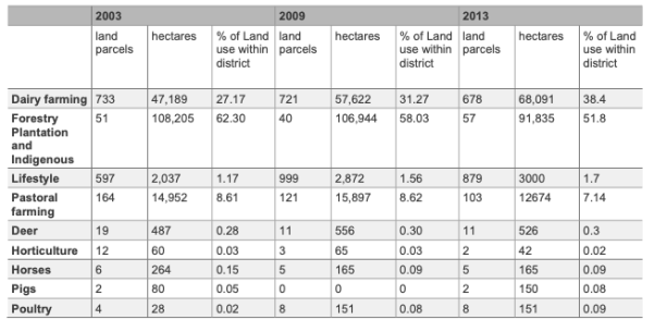
From 2003 to 2013 dairy farming has expanded significantly (from 27% to 38%) while land in forestry has declined (from 62% to 52%) and pastoral farming has declined (from 9% to 7%. Intensification has largely occurred around the conversion of forestry land to dairying. Dairy units have increased in land area and this has been accompanied by an increase in the average herd size. It is unclear whether this trend will and can continue. However, this change is affecting land cover, indigenous biodiversity, natural character and changing rural amenities particularly on the margins of water bodies. These effects cumulatively are impacting on the Waikato River catchment environment undermining the health and wellbeing of the Waikato River. Allowing these adverse environmental effects to continue and not to address them in district planning is not consistent with giving effect to the Vision and Strategy for the Waikato River. This is a major challenge for the district and regional communities. The consensus view is that a collaborative approach is necessary to address in a sustainable way improvements to the management of activities in the catchment and by doing this, give effect to the Vision for the Waikato River.
Whilst the health and wellbeing of the Waikato River affects the community as a whole, the river is of special importance to the Tangata Whenua. Raukawa consider that the degradation affects the mauri of the waterways in the catchment, wāhi tapu and other sites of significance along the margins of these waterways, and the health and wellbeing of Raukawa and the wider community.
The Ngāti Tūwharetoa, Raukawa and Te Arawa River Iwi Waikato River Act 2010 established a co-management regime for the upper Waikato River, which includes all of the Waikato catchment within the South Waikato District. This regime sees partnerships established between Tangata Whenua and the Crown, the regional council and district councils. Joint management agreements between Raukawa and the Council, and between Te Arawa River Iwi and the Council in relation to management arrangements for the River and activities within the catchment affecting the River will be have been developed and will guide the partnership.
As set out in Part 1 Statutory Context, the Vision and Strategy for the Waikato River (Te Ture Whaimana o Te Awa o Waikato) is the primary direction-setting document for the River and activities within its catchment affecting the River. It forms part of the RPS and must be given effect to by the district plan. It identifies a Vision for the Waikato River, and objectives and strategies to realise the Vision.
The Raukawa Environmental Management Plan 2015 and an Upper Waikato River Integrated Management Plan will also have bearing on decision-making within the catchment.
The district plan seeks to give effect to the Vision and Strategy, within Council’s statutory functions as a territorial authority. Safeguarding the mauri of the Waikato River and other waterways is recognised in the plan as vitally important.
6.7 Urban Form and Development
To be provided for as part of the Growth Plan Changes