7 Energy, Infrastructure and Transport
7.3-TRAN Transport
Issues
This chapter describes the significance of transport in the district and outlines the management approach adopted to manage these physical resources.
As the main north-south link and the primary national state highway, State Highway 1 is a critical component of the transport network within the Central North Island for the movement of people and freight. The security of this route is important, not only for the sub-region, but also for other parts of the country as well. State Highway 5 is an important sub-regional route providing access to Rotorua to the east, particularly for tourism. Both highways need to be protected and developed through appropriate land-use planning and transport network integration.
State Highway 30 provides an east-west connection from Waitomo and Otorohanga which has potential to be a major tourism route through the District. Opportunities to strengthen the tourist route links through South Waikato between Waitomo, Taupō and Rotorua need to be recognised and developed to allow for economic growth in this sector. State Highways 27, 28 and 32 are also of strategic importance.
There is capacity within the rail network, particularly the Kinleith Branch rail line, to accommodate increased freight movements. New freight hubs utilising the railway are a possibility to better utilise this capacity.
Infrastructure are physical resources and include infrastructure such as telecommunications, state highways and other roads, and railways.
The District contains utilities that play a key role in New Zealand’s economy and prosperity, particularly with regard to electricity production and transmission, and road transport networks. At the same time these networks underpin the district’s future. Since utility corridors traverse a number of different zones, the plan’s approach is to make them PER throughout the District, subject to consistent standards.
It is recognised that utilities can have significant adverse effects, for example upon important landscapes and significant natural values. In such circumstances, a balance needs to be struck between competing issues associated with natural and physical resource use. Such a balance must be achieved on a case-by-case basis, having regard to the costs, benefits and effects of the particular proposal.
This chapter also establishes the standards relating to the provision of on-site car parking, loading spaces and vehicle access. Standards specify the number of car parking and loading spaces that should be provided for different land-use activities and within different zones. The purpose of this is to manage demand for street-based and public car parking to avoid affecting the safe and efficient operation of the road network. The intended outcome within most of the zones is to ensure that adequate car parking and loading spaces are provided within each property to provide for the demand generated by activities on that property.
The National Policy Statement for Urban Development 2020(NPS-UD) precludes District Plans from requiring car parks within “Tier 3” urban environments. The Urban Area comprising Tokoroa and Kinleith falls within this category, so new developments throughout Tokoroa and in the Industrial zone at Kinleith are not required to provide a minimum number of parking spaces under the Plan.
The NPD-UD does not apply to the smaller towns of Putaruru and Tīrau, so minimum parking requirements have been retained there, except in the Town Centre zones. The town centres of Putaruru and Tīrau are managed differently because of the extent of public car parking available, the presence of service lanes, and the more compact form of development characteristic of these areas.
State Highway 1 runs through the town centres of Putaruru and Tīrau, and next to the Tokoroa town centre. Each of the towns has a different layout and intensity of land-use alongside the state highway, and the interface between the state highway and commercial properties is of importance. This rule chapter does not include a roading hierarchy, although a distinction is made within some of the standards between state highway and local road. The state highway network provides critical transport links both within the district and linking the district to the wider region. Therefore, maintaining the safety and efficiency of the state highway network is important.
In all three town centres and the Tokoroa suburban shops, the majority of car parking is provided as street-based parking or within public parking areas. Any on-site car parking is primarily used as staff parking. The lack of car parking standards for the town centre zones for Putaruru and Tīrau aim to primarily maintain the status quo of limited on-site car parking, and substantial use of street-based and public parking.
Vehicle access to properties needs to be provided in a manner that ensures the safe and efficient operation of the road network. This is particularly important for the district’s state highways where traffic volumes are highest. Standards have been formulated to manage the number and location of vehicle entrances to properties. Vehicle entrances on existing properties may need to be upgraded where traffic generation on the property is increasing substantially.
The traffic generated by a particular development can have a substantial impact on the safety and efficiency of the road network. Localised upgrades of intersections and portions of road may be required in some instances (such as where a significant increase in traffic generation is occurring due to a change in land-use activity) as a condition of resource consent. This rule chapter is intended to operate in conjunction with the zone provisions that manage the type and scale of land-uses in particular areas. Generally, an activity with the potential to generate traffic volumes that may detrimentally affect the safety or efficiency of the road network, or the amenity of the locality, will be a discretionary or non-complying activity within the zone provisions applying to that area.
The WRITS adopted by Council in July 2018 provide much of the technical detail that relates to parking, loading and access requirements. The WRITS is a reference document providing detail on design standards to inform developers and Council staff as to how compliance should be achieved.
Where land-use consent is to be granted for a shortfall in on-site car parking, there are several mitigation options that can be utilised through Council imposing resource consent conditions. These include a consent condition requiring a financial contribution to be paid in lieu of providing on-site car parking, with Council then using the collected parking contributions to provide extra parking spaces on public land in an appropriate location to alleviate any shortfall. Such contributions shall be paid prior to the commencement of the activity, or as stated in the conditions of the resource consent.
Other mitigation options that will be considered include a developer constructing additional parking spaces on the adjoining street frontage, the sharing of parking spaces between activities on different sites, leasing of land nearby to provide parking spaces, use of stacked parking, and provision of cycle spaces or other measures recommended by a suitably-qualified Traffic Engineer, to reduce carparking demand.
Objectives
TRAN-O1
To enable the town centres in Putaruru, Tokoroa and Tīrau to provide distinctive, attractive, safe and easily accessible environments with a concentration of commercial businesses and cultural activities providing a wide range of services and facilities for residents and passing travellers, and with minimum adverse effects on the safe and sustainable functioning of State Highway 1.
TRAN-O2
To provide for outward expansion of existing townships where the new areas can be efficiently serviced with cycling and pedestrians, and where funding provision has been made consistent with the level of projected demand for new building sites for houses and businesses.
TRAN-O3
To ensure safe and efficient land-use, subdivision and development, well-integrated with the functions of different roads, and which is designed to provide for appropriate alternative transport modes (particularly walking and cycling).
TRAN-O4
To ensure that an integrated, efficient, safe and sustainable transportation network is maintained and enhanced to support the social and economic wellbeing of people and communities in the District including provision for active transport and physical activity options
TRAN-O5
To provide for the sustainable, secure and efficient use and development of infrastructure within the District, while seeking to avoid, remedy or mitigate adverse effects on the environment recognising the technical, locational and operational requirements and constraints of the infrastructure concerned.
TRAN-O6
To provide for the important strategic transport networks, in the District and safeguard them from the reverse sensitivity effects of inappropriate subdivision, use and development.
TRAN-O7
To ensure that new urban development is efficiently serviced and integrated to mitigate adverse effects on existing network utilities and infrastructure, and the health, safety and wellbeing of people and communities.
Policies
TRAN-P1
Promote affordable, safe, integrated, sustainable and responsive transport networks within and through the towns, with safe pedestrian and cycleway connections linking residential neighbourhoods with public reserves, schools and the town centres.
TRAN-P2
Ensure that new activities within Putaruru Growth Cell 4 do not cause adverse traffic safety, efficiency or capacity effects on the operation of the SH1/Princes St intersection.
TRAN-P3
Consolidate new residential development in the existing vacant, zoned and serviced land, and in the Putaruru Growth Cells identified by this Plan, in order to achieve the efficient use of existing network utilities and infrastructure.
TRAN-P4
Ensure that new subdivisions within Putaruru Growth Cells do not compromise their efficient servicing, or their integration with the existing urban area as new neighbourhoods.
TRAN-P5
New activities shall not establish in Putaruru Growth Cell 4 (Business) shown on the Planning Maps prior to the formation to the appropriate standard and vesting in Council of the Possible Future Road identified on the Planning Maps connecting Growth Cell 4 and Princes Street.
TRAN-P6
Protect the safety and efficiency of the land transport network from the adverse effects of inappropriate noise-sensitive activities located close to State Highways and designated rail corridors.
TRAN-P7
Ensure vehicle access onto the transportation network does not adversely affect to a more than minor extent the safety, efficiency operation and maintenance of these roads and other road users.
TRAN-P8
Require financial contributions for the provision of car parking where this cannot be provided by an activity or development to the extent required on-site.
TRAN-P9
Establish networks of parks and walkways along the urban streams to provide linkage between neighbourhoods.
TRAN-P10
Development should be located, designed and managed to minimise the need to travel, minimise conflict to and across arterial routes, and provide appropriate access.
TRAN-P11
Manage use and development that may adversely affect the existing operation of network utilities and infrastructure and related activities.
TRAN-P12
Enable infrastructure development where the associated effects are avoided, remedied or mitigated and the functional requirements of the developer and operator of the network utilities and infrastructure are considered.
TRAN-P13
Manage infrastructure development to ensure it does not adversely affect the health and wellbeing of the Waikato River.
TRAN-Rules
TRAN-R1 PER Activities all zones |
Subject to |
(1) Construction, operation, and upgrading of roads and railways within the existing road reserve or railway, including stockpiling roading materials, ballast and sleepers |
(a) TRAN-R4 to R6 (b) TRAN-R9 (c) Consent from the road controlling authority is also required for any work within the road reserve. Council’s WRITS also sets engineering standards for certain works.
|
(2) Creation of new railway sidings, or realignment or extension of existing roads or creation of new roads as a result of a subdivision | |
(3) Street lighting and street furniture | |
(4) Railway crossing warning devices and barrier arms | |
(5) All works proposed by a network utility operator and authorised under road opening notice procedures. | |
TRAN-R2 RDIS activities within TCZ-Tirau |
Subject to |
(1) Any PER Activities (CON Activities) which do not comply with any of the relevant standards shall be a RDIS activity |
(a) AA-R3(1) and AA-R3(2) (b) TRAN-R4 to R6 (c) TRAN-R7 (d) TRAN-R9 as a guide |
TRAN-R3 DIS Activities |
Subject to |
(1) Network utilities and infrastructure for transportation, not otherwise specified as PER, CON or RDIS activities |
(a) AA-R4 (b) TRAN-R8 in PREC1-Putaruru (c) TRAN-R9 as a guide |
TRAN-R4-NC Activities PREC1-Putaruru |
Subject to |
(1) Activities within Putaruru Growth Cell 4 shown on the Planning Maps (GC4) that result in a cumulative increase in vehicle movements to and from GC4 at the Princes St/SH1 Intersection for more than 330 vehicle movements in any given peak hour, taking into account the level of traffic generated by the other land-uses that have been lawfully established or granted consent to establish in the Growth Cell. |
RMA provisions |
(2) Non-compliance with TRAN-R6(3)(b)-Provision of New Road to Putaruru Growth Cell 4 (COMZ) |
TRAN-R4-Zoning of roads
Refer to 15.3
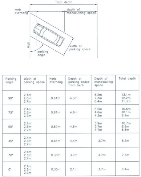
TRAN-R5 Parking, Loading and Access
The following standards apply in all zones, except where otherwise stated below. If the activity is a DIS or NC Activity, the standards below will be used as a guideline to assess the adequacy or otherwise of the parking, loading and access arrangements being proposed.
R5(1) Provision of Vehicle Parking
(a) Where a change of use occurs requiring a greater provision of car parking, or where the floor area of a building is increased, additional on-site car parking will be required in accordance with the standards in Table 4.
Table 4 – Parking Requirements
Use of site |
Zones Where Standard is Applicable |
Parking Spaces Required |
All land-uses |
All zones within the Tokoroa Urban Area, TCZ, and the GIZ at Kinleith |
No car parking required |
Retail activities, Commercial services, unlicensed cafes and restaurants on sites with frontage to Arapuni Road |
MU- SETZ |
No carparking required |
Residential units, including residential accommodation, and caretakers’ accommodation. |
All zones except within the zones of the Tokoroa Urban Area, and the GIZ at Kinleith |
1 space per household unit. |
Retail activities, (except supermarkets), Offices |
All zones, except TCZ, MU-SETZ, within the zones Tokoroa Urban Area, and GIZ at Kinleith |
1 space per 25 m2 |
Supermarkets |
All zones, except TCZ and within the zones of Tokoroa Urban Area |
1 for every 20m2 GFA for the retail floor space open to the public, plus 1 for every 40m2 GFA of floor space that is not open to the public (including food preparation areas, offices, staff recreation, and ablution uses, and ancillary storage space). |
Community facility |
All zones, except TCZ and within the zones of the Tokoroa Urban Area, and GIZ at Kinleith |
1 space per 10 persons the facility is designed to accommodate. |
Craft workshops and studios |
All zones, except TCZ and within the zones of the Tokoroa Urban Area |
1 space per full time equivalent employee. |
Health Care Services and veterinary services |
All zones, except TCZ and within the zones of Tokoroa Urban Area, and the GIZ at Kinleith |
2 spaces for every practitioner on the premises at any one time. |
Commercial services |
All zones, except TCZ, MU-SETZ and within the zones of Tokoroa Urban Area |
1 space per 25m2GFA. |
Home business |
All zones except within the GRZ in Tokoroa. |
1 additional space (to that required for the residential unit) per full time equivalent employee not residing at the site. |
Marae development and papakāinga |
All zones |
1 space per household unit, and 1 space per 10 persons the facility is designed to accommodate for non- residential forms of marae development. |
Community care housing |
All zones except within the GRZ in Tokoroa |
1 space per full time equivalent staff member, and 1 space for every 5 beds. |
Outdoor recreation and sporting activities on parks and reserves. |
All zones except within the zones of Tokoroa Urban Area |
Six spaces per playing field or court. |
Indoor recreation and sporting facilities. |
All zones except within the zones of the Tokoroa Urban Area |
1 space per 10 persons the facility is designed to accommodate. |
Educational facilities |
All zones except within the zones of Tokoroa Urban Area and GIZ at Kinleith |
Primary and Intermediate Schools: 2 spaces per 3 full time equivalent staff. Secondary Schools: 2 spaces per 3 full time equivalent staff and 1 space per 50 students. Tertiary and other education facilities: 1 space per 5 full time equivalent staff members and students. Childcare facilities: 1 space per full time equivalent staff member and 1 space per 8 attendees. |
Hospitals and Homes for the Aged |
All zones except within the zones of Tokoroa Urban Area |
2 spaces for every practitioner on the premises at any one time, and 1 space for every 5 beds. |
Housing for the Elderly |
All zones except within the zones of Tokoroa Urban Area |
1 space per residential unit |
Visitor accommodation |
All zones except within the zones of Tokoroa Urban Area |
1 space per guest room or 1 space for every 5 beds |
Restaurants, bars and cafes |
All zones except for TCZ, MU-SETZ, and within the zones of Tokoroa Urban Area and GIZ at Kinleith |
1 space per 10m2 of customer area* for bars and 1 space per 15m2 of customer area* for restaurants and cafes |
Industrial Activities with a GFA of over 2,000m2 |
GIZ at Tīrau, Putaruru, and Lichfield
|
1 space per maximum number of personnel expected to be on site. |
Other Industrial activities |
GIZ at Tirau, Putaruru, and Lichfield |
1 space per 100m2GFA |
Industrial activities |
COMZ-PREC1-Putaruru |
1 space per 50m2 GFA |
Service industry |
All zones, except within the zones of Tokoroa Urban Area and the GIZ at Kinleith |
1 space per 50m2 GFA. |
Service stations including motor vehicle repair |
All zones, except within the zones of Tokoroa Urban Area and the GIZ at Kinleith
|
2 spaces per 3 staff on duty and 2 customer spaces per shop, 4 spaces per workshop bay, and 3 queuing spaces for carwash, and 1 space for air hose or vacuum. |
Any other PER or CON Activity. |
GRUZ, SP-ELG, RLZ |
No car parking required. |
*Customer area includes any part of the site and public road used as part of the premises and that is open to patrons, e.g. outdoor seating areas
(b) All parking spaces shall be formed and sealed or otherwise maintained to the satisfaction of Council so as to avoid creating a dust nuisance or permit vehicles to carry material such as mud, stone, chip or gravel onto the public road or footpath
(c) The dimensions and layout of parking spaces shall be in accordance with Figure 3, and the spaces shall be marked to delineate the parking space
(d) Every parking space shall be provided with the necessary manoeuvring space and access from and to the road, without requiring another vehicle to be moved
(e) All required parking and manoeuvring space shall be kept clear to ensure it is able to be used for its intended purpose
Figure 3 – Parking Dimensions
(f) Parking spaces shall have a gradient of no more than 1 in 8 in any one direction
g) Where the assessment of the number of parking spaces results in a fractional space being required, any fraction less than half shall be disregarded. Fractions of one half or greater shall be considered as a requirement for one more parking space
(h) Where activity on the site involves more than one category of land-use, and those uses are unlikely to occur at the same time, parking will be calculated in relation to the activity having the greatest requirement. For a multi-purpose site where more than one facility may be used at the same time, the total parking requirements for each facility will have to be provided
(i) All on-site parking spaces and manoeuvring areas shall be located on the site containing the activity that they are intended to serve.
R5(2) Provision of Loading Spaces
(a) Where a change of use occurs that would increase the amount of goods handling by an activity, or where the floor area of a building is increased, an off-street loading space shall be provided in the following circumstances:
(i) on every site in the GIZ and the COMZ except those sites where loading can be undertaken from an adjoining formed service lane, and except where the landowner is able to demonstrate that there are sufficient loading spaces on-site for the demand generated by any change of use or increase in floor area.
(ii) on every site in the TCZ, except those sites where loading can be undertaken from an adjoining formed service lane.
(b) Loading spaces shall have a minimum width of 4 metres and a minimum depth of 8.5 metres
(c) All loading spaces shall be accessible at all times and not used for other purposes
(d) Loading spaces are not required in rural areas, however, all stock loading races and other loading/unloading facilities shall be located to avoid any vehicles undertaking loading or unloading on a public road.
R5(3) Vehicle Manoeuvring
On-site vehicle manoeuvring (such that reversing onto a road is avoided) is required to be provided for every parking and loading space provided on-site, in the following circumstances:
(a) Where a site bounds a state highway
(b) Where a site bounds a road with a posted speed limit of 70km per hour or greater
(c) Where any vehicle entrance serves more than 3 required parking and/or loading spaces; or
(d) Where a site is a rear site with vehicle access provided by an accessway in excess of 30 metres in length.
R5(4) Access
(a) A formed vehicle crossing shall be provided to each site in accordance with Table 5, including on sites where there is an existing crossing but where the character, intensity or scale of the land-use activity increases
(b) Accessway gradients shall not exceed 1 in 6
(c) Vehicle crossings onto state highways shall comply with Table 6 or comply with NZTA requirements.
Table 5: Vehicle Crossing Widths
Type of Vehicle Crossing |
Minimum Crossing Width |
Maximum Crossing Width |
Residential |
3.5 metres |
5 metres |
Rural |
4.5 metres |
8 metres |
Commercial and Industrial |
4.5 metres |
12 metres |
The maximum vehicle crossing width for Emergency Service Facilities is 12m
Table 6: State Highway Crossing Places
Posted speed limit (km/h) |
85th percentile operating speed (or if not known, posted speed limit plus 10km/h) |
Minimum sight distance (m) |
Minimum distance between accessway & nearest intersection (m) |
Minimum distance between local road accessway & intersection (m) |
Minimum distance between accessways (m) |
Not applicable |
50 |
89 |
30 |
20 |
- |
50 |
60 |
113 |
30 |
20 |
- |
60 |
70 |
140 |
30 |
20 |
- |
70 |
80 |
170 |
100 |
45 |
40 |
80 |
90 |
203 |
100 |
45 |
100 |
90 |
100 |
240 |
200 |
60 |
200 |
100 |
110 |
282 |
200 |
60 |
200 |
TRAN-R6 Vehicle Movements and Access
TRAN-R6(1) – GRZ, TCZ, COMZ- All PREC’s
(a) No new direct vehicle accesses onto the state highway shall be created
(b) Activities accessing a state highway shall not result in an increase in traffic that exceeds 100 vehicle movements in any given peak hour, except for the Tokoroa Hospital Site in GRZ-PREC3
(c) Activities accessing a local road, except for activities within Putaruru Growth Cell 4 shown on the Planning Maps, shall not result in an increase in traffic that exceeds 200 vehicle movements in any given peak hour
TRAN-R6(2) – GRZ-PREC3-Tokoroa
(a) Any addition to the existing gross floor area of the Tokoroa Hospital site shall not generate more than 50 additional vehicle movements in any given peak hour where accessing State Highway 32. (As of November 2014 the gross floor area at the hospital is 8268 m2)
TRAN-R6(3)-COMZ-PREC1-Putaruru
(a) Activities within Putaruru Growth Cell 4 shown on the Planning Maps (GC4) shall not result in a cumulative increase in vehicle movements to and from GC4 at the Princes St/SH1 Intersection of more than 200 vehicle movements in any given peak hour. Compliance with this rule shall be demonstrated by an Integrated Traffic Assessment (ITA) prepared by a suitably qualified and experienced person, taking into account the level of traffic generated by any other land-use which has been lawfully established or granted consent to establish in the Growth Cell. The ITA shall include a record of the outcomes from consultation with the NZTA relating to the proposal’s potential traffic and safety effects on the State Highway network and the SH1/Princes Street intersection.
(b) Any development of the land within Putaruru Growth Cell 4 (COMZ) shown on the Planning Maps for a CON, RDIS, or DIS activity shall gain access to that activity from Princes Street by way of a legal road vested in Council on the land identified as Possible Future Road and shown on the Planning Maps.
TRAN-R6(4)- GIZ and RLZ
(a) No new direct vehicle accesses onto the state highway shall be created.
TRAN-R6(5)- GRUZ
(a) Activities that generate traffic from a site shall not exceed 100 vehicle movements per day. For the purpose of this rule:
(i) The number of ‘vehicle movements per day’ is determined on the basis of an average day as measured over a year of the operation of the activity
(ii) Any land in a separate certificate of title shall be regarded as a ‘site’, regardless of whether it is used or owned together with other land titles
(iii) A truck movement shall be considered the equivalent of 10 vehicle movements
This rule shall not apply to traffic movements involved in forest harvesting.
TRAN-R7 Matters of Discretion for RDIS Activities
(1) In assessing applications for activities that involve new direct accesses onto state highways, or generate more than 100 additional vehicle movements in any given peak hour onto a state highway, the matters in respect of which Council has restricted its discretion are:
(a) Location and scale of activity, and location of vehicle entrance
(b) Vehicle access and manoeuvring
(c) Impacts on the safe and efficient functioning of the road network, and
(d) Vehicle queuing on-site
(e) Economic development within the District including the creation of new jobs
(2) In assessing applications for activities that generate more than 200 additional vehicle movements in any given peak hour onto a local road, the matters in respect of which Council has restricted its discretion are:
(a) Location and scale of activity
(b) Vehicle access and manoeuvring
(c) Impacts on the safe and efficient functioning of the road network, and
(d) Vehicle queuing on-site
(e) Capacity and ability of Council’s existing roading infrastructure to accommodate additional vehicle movements
(f) Economic development within the District including the creation of new jobs
(3) In assessing applications for the Tokoroa Hospital site that generate more than 50 additional vehicle movements in any given peak hour onto State Highway 32 from activities occupying additional gross floor area, the matters in respect of which Council has restricted its discretion are:
(a) Location and scale of the activity
(b) Vehicle access and manoeuvring
(c) Impacts on the safe and efficient functioning of the State Highway network, and
(d) Vehicle queuing on-site.
(4) In assessing applications for activities within Putaruru Growth Cell 4 shown on the Planning Maps (GC4) that do not comply with TRAN-R6(3)(a) because they would result in a cumulative increase in vehicle movements to and from GC4 at the Princes St/SH1 Intersection of more than 200 vehicle movements in any given peak hour, the matters in respect of which Council has restricted its discretion are:
(a) Location and scale of activity
(b) Vehicle access, vehicle queuing and manoeuvring on-site
(c) Impacts on the safe and efficient functioning of the road network, and
(d) Capacity and ability of Council’s existing roading infrastructure to accommodate additional vehicle movements
(e) Measures to mitigate any adverse effects on the Princes St/SH1 intersection, taking into account the level of traffic generated by other land-use which has been lawfully established or granted consent to establish in the Growth Cell. This mitigation could include funding physical improvements to the intersection.
(f) Where roading infrastructure is required to be upgraded, the preparation of an infrastructure funding agreement or other such measure that must be agreed with all relevant service providers to ensure that the infrastructure required to service the development can be funded and provided in a timely manner.
(5) In assessing applications which have become RDIS activities due to non-compliance with parking space provision except for within the Urban Area of Tokoroa and Kinleith, other mitigation options that will be considered include a developer constructing additional parking spaces on the adjoining street frontage, the sharing of parking spaces between activities on different sites, leasing of land nearby to provide parking spaces, use of stacked parking, and provision of cycle spaces or other matters recommended by a suitably-qualified Traffic Engineer (e.g. availability of public carparking spaces).
These forms of mitigation are only likely to be appropriate where they do not adversely affect traffic safety or efficiency, and do not preclude on-street parking being available for adjoining land-uses.
TRAN-R8 DIS Activities in Putaruru Growth Cell 4
(1) Retail activities, community facilities and other activities which are DISC in the Putaruru Business zone within Putaruru Growth Cell 4 shown on the Planning Maps, since they are not CON activities under COMZ-R(2), should:
(a) Mitigate any adverse effects on the Princes St/SH1 intersection, as demonstrated by an Integrated Traffic Assessment prepared by a suitably qualified and experienced person, taking into account the level of traffic generated by other land-use which has been lawfully established or granted consent to establish in the Growth Cell. This mitigation could include funding physical improvements to the intersection.
(2) For Putaruru Growth Cell 4 (Business) as shown on the Planning Maps, the design and location of the legal road providing access to Princes Street shown as Possible Future Road on the Planning Maps where this has not already been vested in Council.
TRAN-R9- Other Plan Matters
The following also may be relevant:
(1) Section 7.1 Energy, 7.2 Infrastructure
(2) Section 8.1 Contaminated Land, 8.2 Hazardous Substances, 8.3 Natural Hazards
(3) Section 9.1 Historic Heritage, 9.2 Sites and Areas of Significance to Māori
(4) 10.1 Ecosystems and Indigenous Biodiversity, 10.2 Natural Character, 10.3 Natural Features and Landscapes, 10.4 Public Access
(5) Chapter 11 Subdivision
(6) Section 12.1 All Activities
(7) Section 12.2 Activities on the Surface of Water, 12.3 Air Emissions, 12.4 Earthworks, 12.5 Financial Contribution, 12.6 Light,12.7 Noise, 12.8 Signs, 12.9 Temporary Activities
(8) Part 3- Any relevant zone or overlay
TRAN- Other Methods
TRAN-M1
Development of the District’s transport systems that is consistent with the Regional Land Transport Strategy.
TRAN-M2
Design standards for transport infrastructure to maximise public safety and to avoid or mitigate adverse effects on the environment.
TRAN-M3
A roading hierarchy maintained and monitored within the District.
TRAN-M4
Consent may be required from the WRC for many of the above activities, under the Waikato Regional Plan.
TRAN-M5
Works within road reserve administered by SWDC requires approval of Council as the ‘road controlling authority’. Council issues ‘street opening notices’ for works on local road reserve
TRAN-M6
The WRITS adopted by Council in July 2018 should be referred to for the technical specifications for construction of vehicle crossings and accessways
TRAN- Anticipated Results
TRAN-AER1
That within the district’s smaller towns and rural areas (i.e. except for within the Urban Area comprising of Tokoroa and Kinleith) adequate on-site car parking is provided in relation to the anticipated demand for parking generated by the activity.
TRAN-AER2
That within all the town centres the on-site parking provision is maintained at approximately the existing level. The majority of car parking will continue to be provided as street-based parking or within public parking areas.
TRAN-AER3
That sufficient numbers of loading spaces continue to be provided in the town centres, commercial and industrial parts of the district (either on streets or within properties) in convenient locations to satisfy demand
TRAN-AER4
That subdivision, use and development of land occurs in a manner that avoids detrimental effects on the safety and efficiency of the roading network, particularly state highways.