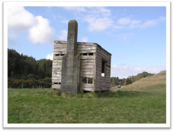
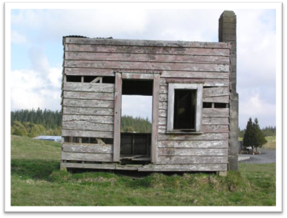
HH-35: Stockmans Hut
Date of Photograph: 29/07/2008
Location and Zoning Information | |
Address |
2670 State Highway 5, Tirau |
Current Owner |
Duncan Processors Ltd. |
Legal Description |
Section 50 Block X Paterere North East Survey District (Selwyn Settlement) CT 991/187 |
Zoning |
General Rural Zone |
Valuation Number |
0541129200 |
Google Maps Link |
|
Architecture | |
Date of Construction |
1935 - 1940; fire place circa early 1950s |
Materials |
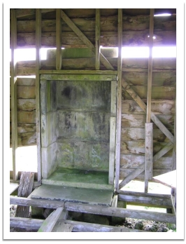
Wooden weather boards; single skin of exterior weather boards on a timber frame. Concrete piles and pre-cast concrete block fireplace. Round nails, rose-head and flat top used to attach boards, repair (re-nailing) is evident. The frame is lashed to the concrete piles with #8 wire (see additional photos). The wire feeds through holes in the piles. The roof is corrugated iron. No metal door or window hardware was evident |
Architecture/Engineer/Builder |
TS Duncan or more probably Albert Hemmings |
Condition |
Stable Condition and high level of integrity. Many of the floor boards, some of the weatherboards, the windows, and door are missing. No major areas of wet rot were evident. The building appears very stable considering how exposed it is. The hut is not in use nor has it been used for many years. |
Original Site Recommendation |
Barker, Eileen (1986) A History of the Tapapa School and District. McMillan, TE (editor) (1995) The Centennial History of the Matamata Plains. |
Current Use |
Not in use. Popular landscape feature and landmark on the way to and from Rotorua on SH 5. The hut is frequently photographed |
Statement of Significance | |
Historical –The Hut reflects an important or representative aspect of SWD history, (ie development of farming in the district, and agricultural management ideas). Section 50’s history is associated with farming by the Thames Valley Land Company and the leasing by ballot of the Selwyn Settlement block. The paddock (Section 50) and the associated hut relate to the history of land use in the Kaimais and the use of grazing rotation to overcome the ill effects of bush sickness prior to the discovery of the cobalt deficiency. Educational - The stockman’s hut has the potential to be used to educate the public about SWD’s history as an item on a heritage trail or school field trip. Landscape/ Landmark- The hut and associated paddock are a landmark on State Highway 5 for many people. The hut in it’s setting are aesthetically pleasing. The hut is frequently photographed and has been used on calendars (including the Duncan Processing Plan calendar). District Plan RulesDemolition- DIS. Protection focus- Mitigate the effects of demolition by requiring the applicant to provide Historical Building Documentation (HBD) which should include: the structures history, photographic documentation and measurements of the item prior to removal. Additions/ Alterations - Not PER(would have an adverse effect on the integrity of the buildings scale and landmark qualities). Repair of the Structure - PER. Refer to HH-R1. Protection focus- building materials should be similar in type and dimensions to the existing materials. The finish and profile of the exiting building should be respected and replicated. Re-use/Change of Use- Internal Changes - DIS. Protection Focus: building materials should be similar in type and dimensions to the existing materials. The finish and profile of the exiting building should be respected and replicated. Relocation - DIS. Protection focus- Mitigate the effects by 1) Consulting with the local community and/ or consulting with Iwi or special interest groups, 2) Relocating to a similar setting, 3) Documenting (HBD). | |
History | |
The hut is located on a fifty acre block that was part of the Selwyn Settlement Block X which was surveyed off in 1905 (SO 13863). The Selwyn Settlement was a series of blocks east of the Waihou River that extended from the northern side of the Kaimai Road southward for eighteen miles along the foot of the ranges to beyond Lichfield. The south-eastern part of the area encompassed the edge of the Patetere Plateau. The Selwyn Settlement was part of the Thames Valley Land Company estate prior to Government acquisition in 1905. The Thames Valley Land Company had acquired the blocks from the Patetere Company in 1883. Thames Valley Land Company liquidated their holdings in 1891 as a result of the economic depression of the 1880’s. The Bank of New Zealand took over the property in 1891 and it was administered by the Assets Administration Board in 1895 and taken over by the Government in 1905. The Selwyn Settlement comprised 37,444 acres and was divided into 24 farms. Some of the farm allotments were composed of groupings of land, one section in open country and one in the bush country (i.e. Kaharoa- “Highland Farm”). The land was offered by ballot in 1906 for dispersal on lease, with all the improvements, other then buildings, included in the lease price for the section. Survey plan SO 13863 (1905) shows section 50 and the notation “good grass, cocksfoot & c”. Section 50 is set in the middle of a wooded landscape near the Kaharoa Clearing. The description of the paddock indicates the pasture had been cleared and cultivated probably by the Thames Valley Land Company. T.S Duncan was the successful applicant for Sections 81 (248 acres) which included Sections 49 (352 acres) and Section 50 (57 acres). The sections were combined so stock could be rotated since Sections 49 and 50 (near Mamaku) were in the “black ring” or bush sickness area where the soil was cobalt deficient. (The cobalt deficiency was discovered after the discovery that stock rotation solved the problem of stock health in the black ring.) In 1935 Albert Hemming a Mamaku Farmer leased the land as second class land under the land for Settlements Act (1925) for an annual rent of one pound and ten shillings for thirty years (CT 619/241). The capital value of the land was estimated as thirty pounds at the time he leased it. The lease price for section 50 suggests that it probably contained an improvement, such as a well or tank or possibly the Stockman’s Hut. Under the terms of the lease the lessee agreed to put on the land substantial improvements of a permanent character (ie land clearing, weed control, fencing, cultivation, drains, gardens, roads, wells or water tanks, sheep dips, and non-movable buildings.) Albert Hemming owned Hemmings mill on the Old Tapapa Road and kept bullocks for logging on the Waimakariri Road. The Hemmings mill was a small mill that was moved to Okoroire in the 1930’s. Four years after Albert Hemmings leased section 50 the lease was transferred to Cecil Hemmings, farmer, Mamaku (1939, Transmission 43803 CT 619/241). In 1940 Cecil Hemmings transferred the lease to Otto Francis Hemmings of Okororie a Saw Miller (Transmission 321310 CT 619/241). Otto Hemmings paid 60 pounds for the section shown as renewable lease no 1935 (CT199/286). The land value had doubled in five years suggesting improvements had been made. The stockman’s hut may have been added during Albert Hemmings tenure (1935-1939). Albert Hemming had the resources to construct the hut, ie saw mill and a bullock team for lumber transport). The style of the hut and materials used suggest a date of mid 1930 or later. Section 50 was transferred back to Cecil Hemming (farmer) in 1951 and a certificate of title was produced (CT 991/187). The section was sold in 1956 to Laurie H Major, farmer (Tapapa) and in 1966 to Hugh J Lithgow, farmer (Tirau). Section 50 is east of the Tapapa water supply troughs for the accommodation paddocks along the Tapapa/ Rotorua Road (St Hwy 5). During the visit to the hut the manager of Duncan Processors Ltd. noted that he had been told the paddock where the hut was had been used as a resting paddock for stock. He noted that there was considerable interest in the hut and people often stopped to photograph it.
| |
Additional Photographs