16 The Lake Whakamaru Development Area Plan (DAP)
The Lake Whakamaru Development Area is identified in Figure 1 below.
Objective
The Lake Whakamaru DAP has been developed to direct future subdivision and development in the Rural Lifestyle Zone within the Lake Whakamaru Development Area. Any subdivision and development is to be in accordance with Figure 1 and the Lake Whakamaru DAP Components listed below.
Lake Whakamaru DAP Components
1. Vegetation Covenant:
A planted buffer shall be established within all areas identified as a Vegetation Covenant in Figure 1. The purpose of this planting is to provide partial screening and visual separation between the reserve and dwellings and living court areas within the site, for privacy reasons, for ecological reasons, and to help the development within the zone to integrate with the wider surrounding landscape. The planted buffer shall consist of native species endemic to the area and may include species listed in Table 16-1 planted at an average spacing of 1 plant every 1.2m2. The planting within these areas shall be protected by a covenant or consent notice against the title of each lot to ensure that all planting is maintained and managed consistently. A Landscape Delivery and Maintenance Plan (LDMP) will be required as part of the conditions of consent for any subdivision within the zone
2. Landscape Delivery and Maintenance Plan
A LDMP must be prepared in consultation with Council's Parks and Reserves team and submitted with the subdivision application. The purpose of the LDMP is to:
i. Provide direction for the proposed bund and adjacent areas;
ii. Minimise adverse effects on natural character values of the ONL;
iii. Provide a vegetated backdrop, particularly for prospective built form when viewed from eastern and southern directions;
iv. Provide for taller planting within access reserves;
v. Include appropriate pest controls during planting establishment;
vi. Provide a mechanism for assessing planting performance to ensure 90% canopy closure within 5 years of planting; and
vii. Screen dwellings to mitigate potential adverse visual effects on ONL5-Lake Whakamaru and the Whakamaru Gorge section of the Waikato River.
3. Local Purpose Reserves
Local Purpose Reserves shall be created between clusters of residential lots for the visual separation of buildings, public access between roads and the Whakamaru reserve, and for stormwater management purposes.
4. Recreation Reserve
Recreation Reserve areas shall be vested in Council to enable the extension of the Whakamaru camping ground.
5. Visual Mitigation Bund
A minimum 5m wide x 2m high earth bund shall be established along the Ongaroto Road frontage of the site to screen the site from view to help maintain the existing rural character. Planting on the bund will be protected by the Vegetation Covenant.
6. Building Design
All buildings (dwelling and ancillary) shall be designed to visually integrate with the surrounding landscape by placing controls on their height, location and appearance. Buildings shall comply with the following standards:
Maximum height: 6m except where in accordance with RLZ-R6(4)(d).
i. Exterior cladding materials: Natural timber (oiled or stained), painted timber or panel (subject to iii below), concrete (off the form finish, plaster finish or exposed aggregate (subject to iii. below), colour steel (subject to iii. below), natural stone and/or brick, and weathering steel.
ii. Exterior colours and reflectivity: Recessive colours that integrate with the colours and tones found in the surrounding landscape shall be used on all exterior surfaces. Colours that are visually dominant or have a high contrast value shall be avoided. Suitable colours include: Colours from the BS 5252 range (or equivalent) identified in the chart on Plan 2, subject to the following Light Reflectance Value (LRV) restrictions:
(a) Roof colours with an LRV between 5 - 13%
(b) Wall colours with an LRV between 5 - 23%.
(c) Trim colours with an LRV between 5 - 46%
7. Earthworks
The earthworks within each lot are restricted to the formation of the building pads and access, and easing the associated cut and fill batters to integrate with existing contours. The use of retaining walls (visible from outside of the lot) shall be avoided.
8. Fencing and Boundary Treatment
Where possible, boundaries should be unfenced or demarcated by hedging or informal planting. Urban and solid close boarded fencing is not acceptable on street frontages or within the vegetated bund area. If fencing is proposed the majority must be visually permeable and of the same design to maintain rural character. Suitable fencing types and boundary treatments include:
i Horizontal timber post and rail.
ii. Post and wire (farm fencing).
9. Bat Management Plan
A Bat Management Plan (BMP) must be provided with the subdivision application. The BMP must address the following matters:
i. Use of best practice effects management and offsetting methodologies for evaluating, protecting and recreating bat habitats during the design and impact assessment stages of the development;
ii. Appropriate inter-disciplinary mechanism to minimise adverse development and construction effects on the quality of bat habitats;
iii. Use of best practice protocols for tree felling in relation to any trees intended for felling and which have been identified as high or medium value potential roost trees; and
iv. Appropriate pest controls to maintain bat roosting habitats.
10. Lighting
To minimise potential glare and light spill from both carriageway routes and beyond properties, outdoor lighting fixtures shall be downward facing and shielded to minimise light spill beyond the boundary.
Light spill from housing lights, outdoor lights and streetlights should be below 0.3 lux at the western boundary of lots adjoining the Lake Whakamaru Reserve. Buildings must be located at least 5m from the Bat Buffer Zone (BBZ) marked on Chapter 16 Figure 1. If this is achieved, effects of artificial light spill on bat habitat and bat behaviour will likely be minimal.
A temperature of 3000 K or less is required for outdoor and streetlights to avoid adverse effects on bat habitats.
11. Wastewater
Onsite wastewater discharges from all dwellings developed on site are to be treated by secondary treatment systems with all wastewater disposal areas to be planted in appropriate water tolerant vegetation to aid the uptake of water and nutrients from the discharge. A wastewater assessment is to be provided with any resource consent application.
12. Water
Each dwelling shall be required to install onsite rainwater harvesting and storage in rainwater tanks for reuse as potable and non-potable water supply.
Any water tanks required for potable supply or firefighting storage which are fully or partially above-ground are subject to the building design requirements set out in Component 6 of this Development Area. Tanks may be fully buried in the ground as an alternative means to avoid adverse visual effects.
13. Stormwater
Stormwater is to be disposed of on-site for each lot or residential unit, primarily via roof collection and tank storage. Overflows will be managed on site via soakage.
A detailed stormwater assessment and design for subdivision must provide for:
i. Internal road stormwater conveyance via roadside swales.
ii. The swales to be designed at subdivision stage to accommodate conveyance of the 1 in 10 year design event and where site contours allow treatment of the water quality volume. Appropriate stormwater treatment if required to provide additional soakage.
iii. Secondary overland flows to be via the road network and associated reserve corridors. Where secondary overland flow paths for runoff from developed lots are not available to road or reserve areas, appropriate flow paths shall be designated.
iv. A stormwater assessment is required to be provided as part of any Building Consent application.
14. Solid Waste
The subdivision application must demonstrate how solid waste/refuse is to be collected from the site to ensure the development is maintained in a tidy state. Future owners are to be made aware that Council has no responsibility for refuse collection within the Lake Whakamaru Development Area or within the Mangakino or Whakamaru townships.
15. Livestock and animal husbandry
Except for the temporary raising and keeping of young animals for school calf or lamb club activities, no livestock or animal husbandry activities shall be undertaken on the land. Cats are not permitted to be kept within the subdivision. This requirement is to be demonstrated in any subdivision application with an appropriate legal mechanism proposed.
Table 16-1: Typical plant species found in this area
Botanical Name Common Name |
Alectryon excelsus Titoki |
Astelia chathamica |
Chatham Island Astelia |
Aristotelia serrata |
Wineberry/makomako |
Brachyglottis repanda |
Rangiora |
Coprosma robusta |
Glossy karamu |
Cordyline australis |
Ti kouka/cabbage tree |
Cyathea medullaris |
Mamaku, black ponga |
Dacrydium cupressinum |
Rimu |
Fuchsia excorticata |
Kotukutuku, tree fuchsia |
Griselinia littoralis |
Kapuka NZ broadleaf |
Hebe stricta |
Koromiko |
Knightia excelsa |
Rewarewa |
Kunzea robusta |
Kanuka |
Leptospermum scoparium |
Manuka |
Myrsine australis |
Red mapou |
Phormium tenax |
Harakeke/NZ flax |
Phyllocladus trichomanoides |
Tanekaha, celery pine |
Podocarpus totara |
Totara |
Prumnopitys taxifolia |
Matai, black pine |
Pseudopanax arboreus |
Whauwhaupaku, five finger |
Note: Selected species are suggestions/examples of planting only. Final plant list may vary.All plants used for ecological planting to be eco-sourced from the Central Volcanic Plateau Ecological Region | |
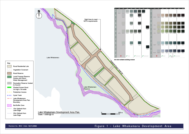
Figure 1 – Lake Whakamaru Development Area